When writing about slum upgrading, I’ve said that I dreamt of a participatory process in which every individual slum dweller could express their needs and ambitions for the slum. Through this process, these people could come up with a master plan that would enable NGOs and public organizations to work hand in hand for the coordinated upgrading of Kibera. Such process does not exist yet. However, I know of one organization that collects and synthetizes data on Kibera, using participatory processes and enhances the work of dozens of civil society organizations. This organization is Map Kibera and is one of my favorite organizations working in the slum.
Map Kibera Genesis
Map Kibera was created in 2010 to fill in Kibera’s ‘information gap’. Its founders noticed that Nairobi City Council mapped the slum as a forest, and that it was absent from online mapping resources such as Google Maps and Open Street Map. In addition, even though many NGOs and public institutions are involved in collecting data on the place, none of this data is displayed at the local level. By introducing participatory mapping in the slum, Map Kibera aims at bridging that gap.
Beyond the envy of improving the information of the field, the organization aims at empowering citizens and giving them a say in the process of governance by teaching them how to report on their own environment. In the informal areas, more resources, reports and studies do not involve community participation in data collection. Teaching people from the community how to collect data is also a way of teaching them how to use that information to report on the hardship they face themselves. It allows greater participation of local people in the democratic process.
Empowering through mapping
The association decided to train 13 young people from the 13 villages of Kibera on how to use OpenStreetMap. During three weeks, and with the assistance of local GIS professionals, Map Kibera collected data through the use of GPS using open source software.
The project started with a feasibility assessment allowing the youth-led organization to locate appropriate places and partners. The incoming partners received training and went into unmapped areas to collect data. They then uploaded data onto the open street map. Afterwards, the partners printed the map and introduced it to the local people. These meetings were aimed at raising awareness and allowing better cohesion between the various villages. In addition, Map Kibera stared with a blog on featuring a wiki space allowing stakeholders to discuss the project’s planning.
One year after its creation, Map Kibera implemented a strategy to allow people to access the information, displaying maps to the rest of the community. Maps are painted on the walls to show people where to access public services. Gathering the data helped members of the community meeting with the local leaders and the various social workers in the slum. Through this, they created a wide network to distribute the maps even more accurately. They also get to know more people who can help gathering more accurate data.
Impacts
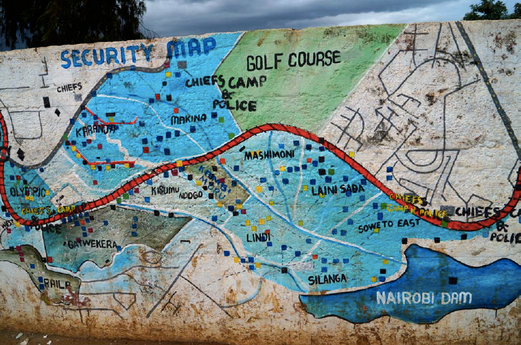
Amongst others, Map Kibera created a security map. This map is extremely useful for the community as it indicates black spots – the areas where it is dangerous to walk by day and night. Thanks to the grassroots knowledge of young people, the mappers were able to locate the places where other unemployed youngsters wander. The lack of income and opportunities in Kibera push them into crime. They take drugs and attack people, usually causing serious injuries or death. This map serves the general interest as it allows Kibera dwellers that are coming from a different village to be aware of the places where not to walk.
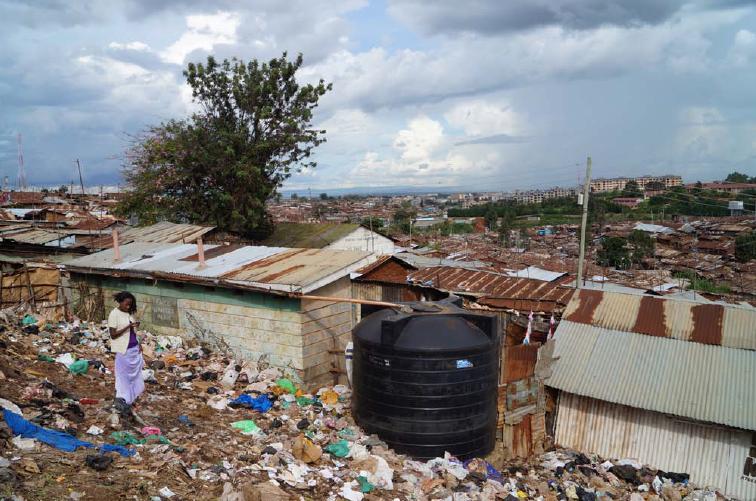
If the maps serve the community, interestingly they also had an impact on improving the urban environment. Maps have an indirect impact on the urban space. In 2010, UNICEF funded another map on water and sanitation in Kibera. However, some of the villages did not have water. Map Kibera was able to partner with the NGO WASUP in order to locate the places with lacked adequate sanitation. With the information, WASUP was able to build water tanks in these areas.
Sustainability at core of the project
The project is economically, socially and environmentally sustainable. Economically, the Trust is working as a firm, selling maps to the various stakeholders and paying young mappers – providing them with employment. They also manage to get income for themselves when funds are available.
The sustainability of the project is also ensured by its ability to improve the state of young people (to a small extent as only a few youth are necessary to collect data for each map) and making each mapper an actor in the development of the slum. At the community level, the information is useful both to the slum dwellers as they are provided with useful information on where to walk or where to find adequate sanitation services. Indirectly, providing other organization with these information has allowed planning for more adequate services throughout the informal settlement.
From coordinating service provision to upgrading the slum
By developing a network of local stakeholders, Map Kibera has managed to become an unavoidable actor in the field. They gather all necessary information for NGOs to work efficiently. They have the necessary information to maximize their impact on the slum and work in a coordinated manner. In that regard, Map Kibera has proven information management to be actually useful in impacting both the community and its urban environment.
Article originellement paru sur le blog de l’auteur : http://carolineguillet.com/2014/05/18/map-kibera-first-step-towards-bottom-up-slum-upgrading/
Map Kibera Website: www.mapkibera.org