Map Kibera: Un premier pas vers l’amélioration ascendante de la vie dans les bidonvilles

security-map
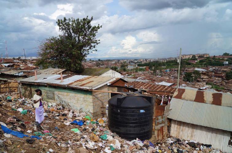
Dans mes articles sur l'amélioration de la vie dans les bidonvilles, j’avais dit que je rêvais d'un processus participatif dans lequel chaque habitant pourrait exprimer ses besoins et ses ambitions pour le bidonville. Grâce à ce processus, ces personnes pourraient proposer  un plan directeur qui permettrait aux ONG et aux organismes publics de travailler ensemble pour une amélioration coordonnée de Kibera. Un tel processus n’existe pas encore. Toutefois, il existe une organisation qui recueille et synthétise des données sur Kibera, en utilisant des processus participatifs et améliore le travail de dizaines d'organisations de la société civile. Cette organisation s'appelle Map Kibera, c'est l'une de mes organisations préférées qui travaille dans le bidonville.


La création de Map Kibera 
Map Kibera a été créé en 2010 pour combler «le manque d'information» dans Kibera. Ses fondateurs ont remarqué que le Conseil municipal de Nairobi avait  cartographié le bidonville comme une forêt et que ce lieu n’existait pas sur  les ressources de  cartographie en ligne telles que Google Maps et Open Street Map. En outre, même si de nombreuses ONG et institutions publiques sont impliquées dans la collecte de données sur place, aucune n’est disponible au niveau  local. En introduisant la cartographie participative dans le bidonville, Map Kibera vise à combler cette lacune.
Au-delà de l'envie d'améliorer l'information sur le  terrain, l'organisation vise à promouvoir l'autonomie des citoyens en leur donner le pouvoir de s’exprimer sur le processus de gouvernance et en leur apprenant à faire des rapports sur leur propre environnement. Dans les zones informelles, les ressources de rapports et d’études n’impliquent pas forcément la communauté dans la collecte de données. Enseigner aux gens de la communauté comment recueillir des données est aussi une façon de leur apprendre à utiliser l’information pour rendre compte des difficultés auxquelles  ils  font face. Cela permet une plus grande participation des populations locales dans le processus démocratique.


L'émancipation par la cartographie
L'association a décidé de former 13 jeunes de 13 villages  différents de Kibera à l'utilisation de Open Street Map. Pendant trois semaines, et avec l'aide de professionnels de SIG locaux, Map Kibera a recueilli des données grâce à l'utilisation du GPS en utilisant un logiciel open source.
Le projet a commencé par une étude de faisabilité permettant aux jeunes de l'organisation d’identifier  les lieux et les partenaires appropriés. Les partenaires entrants ont reçu une formation et sont allés dans des zones non cartographiées pour recueillir des données. Ils ont ensuite téléchargé ces données sur Open Street Map. Puis, les partenaires ont imprimé la carte et l'ont présentée  à la population locale. Ces réunions visaient  à sensibiliser et à permettre une meilleure cohésion entre les différents villages. En outre, Map Kibera a mis sur pied  un blog  avec un espace wiki permettant aux parties prenantes de discuter de la planification du projet.
Un an après sa création, Map Kibera a mis en œuvre une stratégie pour permettre aux gens d'accéder à l'information en affichant des cartes pour la communauté. Les cartes furent peintes sur les murs pour montrer aux gens les accès aux services publics. La collecte des données a aidé à la réunification  des membres de la communauté avec les dirigeants locaux et les différents travailleurs sociaux dans le bidonville. Grâce à cela, ils ont créé un vaste réseau de distribution de cartes d’une plus grande  précision. Ils ont permis également d’identifier  plus de personnes qui pouvaient aider à la collecte de données plus précises.


Impacts
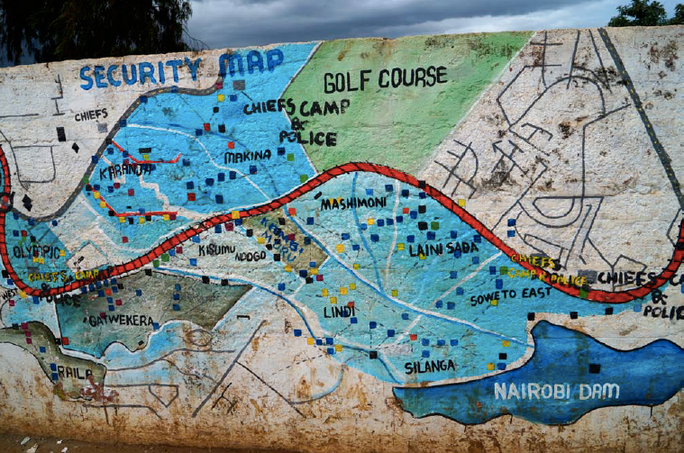
Map Kibera a créé une carte se référant à la sécurité. Cette carte est extrêmement utile pour la communauté car elle indique les taches noires – les zones où il est dangereux de marcher jour et nuit. Grâce  au soutien  de jeunes autochtones, les cartographes ont été en mesure de localiser les endroits où d'autres jeunes chômeurs errent. Le manque de revenus et des opportunités à Kibera les ont poussés au crime. Ils se droguent et attaquent des personnes causant des blessures graves ou la mort. Cette carte sert l'intérêt général car elle permet aux habitants de Kibera qui viennent d'un village différent d'être informés  des endroits dangereux.
Si les cartes aident la communauté, elles ont également eu un impact sur l'amélioration de l'environnement urbain. Les cartes ont un impact indirect sur l'espace urbain. En 2010, l'UNICEF a financé une autre carte sur l'eau et l'assainissement à Kibera. Certains des villages ne disposaient pas d'eau. Map Kibera a été en mesure de travailler en partenariat avec l'ONG WASUP afin de localiser les lieux mal équipés en matière d’assainissement. Grâce à ces informations, WASUP a été en mesure de construire des réservoirs d'eau dans ces zones.


Le développement durable au cœur du projet
Le projet est économiquement, socialement et écologiquement durable. Economiquement, la Fiducie  travaille comme une entreprise, elle vend des cartes à différentes parties prenantes et paient  les jeunes cartographes – leur offrant ainsi  un emploi. Ces derniers parviennent également à gagner de l'argent lorsque les fonds sont disponibles. 
La durabilité du projet est également assurée par sa capacité à améliorer la situation  des jeunes (dans une moindre mesure car seulement quelques personnes sont sollicitées pour recueillir des données pour chaque carte) et à faire de chaque cartographe un acteur dans le développement du bidonville. Au niveau communautaire, l'information est utile pour les habitants du bidonville. Ils sont informés  des endroits dangereux  et de l’emplacement  des services d'assainissement adéquats. Indirectement, l'accès à ces informations par d’autres organisations a permis la planification des services plus adéquats à travers un règlement informel.
De la coordination des services à la remise à niveau du bidonville.
En développant un réseau d'acteurs locaux, Map Kibera a réussi à devenir un acteur incontournable dans le domaine. Ils rassemblent toutes les informations nécessaires pour les ONG afin de leur permettre de travailler efficacement. Ils disposent de l'information nécessaire pour maximiser leur impact sur le bidonville et leur permettre de  travailler  d'une manière coordonnée. À cet égard, Map Kibera a prouvé  que la gestion de l'information peut être réellement utile pour influencer la communauté et son environnement urbain.


                                                                                                                                                      Traduit par Koriangbè Camara


Article originellement paru sur le blog de l'auteur:
http: //carolineguillet.com/2014/05/18/map-kibera-first-step-towards-bottom-up-slum-upgrading/
Map Kibera Site Web: www.mapkibera.org


Map Kibera: first step towards bottom-up slum upgrading

When writing about slum upgrading, I’ve said that I dreamt of a participatory process in which every individual slum dweller could express their needs and ambitions for the slum. Through this process, these people could come up with a master plan that would enable NGOs and public organizations to work hand in hand for the coordinated upgrading of Kibera. Such process does not exist yet. However, I know of one organization that collects and synthetizes data on Kibera, using participatory processes and enhances the work of dozens of civil society organizations. This organization is Map Kibera and is one of my favorite organizations working in the slum.


security-map


Map Kibera Genesis

Map Kibera was created in 2010 to fill in Kibera’s ‘information gap’. Its founders noticed that Nairobi City Council mapped the slum as a forest, and that it was absent from online mapping resources such as Google Maps and Open Street Map. In addition, even though many NGOs and public institutions are involved in collecting data on the place, none of this data is displayed at the local level. By introducing participatory mapping in the slum, Map Kibera aims at bridging that gap.

Beyond the envy of improving the information of the field, the organization aims at empowering citizens and giving them a say in the process of governance by teaching them how to report on their own environment. In the informal areas, more resources, reports and studies do not involve community participation in data collection. Teaching people from the community how to collect data is also a way of teaching them how to use that information to report on the hardship they face themselves. It allows greater participation of local people in the democratic process.

Empowering through mapping

The association decided to train 13 young people from the 13 villages of Kibera on how to use OpenStreetMap. During three weeks, and with the assistance of local GIS professionals, Map Kibera collected data through the use of GPS using open source software.


datacollection


The project started with a feasibility assessment allowing the youth-led organization to locate appropriate places and partners. The incoming partners received training and went into unmapped areas to collect data. They then uploaded data onto the open street map. Afterwards, the partners printed the map and introduced it to the local people. These meetings were aimed at raising awareness and allowing better cohesion between the various villages. In addition, Map Kibera stared with a blog on featuring a wiki space allowing stakeholders to discuss the project’s planning.

One year after its creation, Map Kibera implemented a strategy to allow people to access the information, displaying maps to the rest of the community. Maps are painted on the walls to show people where to access public services. Gathering the data helped members of the community meeting with the local leaders and the various social workers in the slum. Through this, they created a wide network to distribute the maps even more accurately. They also get to know more people who can help gathering more accurate data.

Impacts

Amongst others, Map Kibera created a security map. This map is extremely useful for the community as it indicates black spots – the areas where it is dangerous to walk by day and night. Thanks to the grassroots knowledge of young people, the mappers were able to locate the places where other unemployed youngsters wander. The lack of income and opportunities in Kibera push them into crime. They take drugs and attack people, usually causing serious injuries or death. This map serves the general interest as it allows Kibera dwellers that are coming from a different village to be aware of the places where not to walk.

If the maps serve the community, interestingly they also had an impact on improving the urban environment. Maps have an indirect impact on the urban space. In 2010, UNICEF funded another map on water and sanitation in Kibera. However, some of the villages did not have water. Map Kibera was able to partner with the NGO WASUP in order to locate the places with lacked adequate sanitation. With the information, WASUP was able to build water tanks in these areas.

Sustainability at core of the project

The project is economically, socially and environmentally sustainable. Economically, the Trust is working as a firm, selling maps to the various stakeholders and paying young mappers – providing them with employment. They also manage to get income for themselves when funds are available.

The sustainability of the project is also ensured by its ability to improve the state of young people (to a small extent as only a few youth are necessary to collect data for each map) and making each mapper an actor in the development of the slum. At the community level, the information is useful both to the slum dwellers as they are provided with useful information on where to walk or where to find adequate sanitation services. Indirectly, providing other organization with these information has allowed planning for more adequate services throughout the informal settlement.

From coordinating service provision to upgrading the slum

By developing a network of local stakeholders, Map Kibera has managed to become an unavoidable actor in the field. They gather all necessary information for NGOs to work efficiently. They have the necessary information to maximize their impact on the slum and work in a coordinated manner. In that regard, Map Kibera has proven information management to be actually useful in impacting both the community and its urban environment.


Article originellement paru sur le blog de l’auteur : http://carolineguillet.com/2014/05/18/map-kibera-first-step-towards-bottom-up-slum-upgrading/

Map Kibera Website: www.mapkibera.org

The Architect Project: Development through Architecture in Accra

Improving the living and housing conditions of developing metropolises is a challenge that lots of disciplines – engineers, urban planners, health and education specialists, to name a few – have undertaken. As an urban planner, I was inevitably convinced that planning was the key to identify and address the complex and intricate issues people living in slums are facing. Engaging with Juliet Sakyi-Ansah, the Founder of The Architects’ Project (#tap) in Accra opened my mind on the strength of architecture as a new tool for development. The Architects’ Project illustrates the eagerness of young people of Ghana to address relevantly the issues they are facing and highlights the importance of creativity in places characterized by numerous challenges.

tap 3 redim

Accra and the failure of Urban Planning

Accra is one of the most populous cities in Africa, with 2.3 million dwellers in 2013, and with an estimated population increase of 4.3% per year, one of the fastest growing. Like many developing metropolises, the population increase applies immense pressure on city planning and an estimated 58% of the population lives in inadequate housing (UN-Habitat Ghana: Accra Urban Profile, 2009).

Yet, the lack of adequate housing and infrastructure cannot be explained by population pressure alone: it is also the result of huge urban sprawl and the weakness of city institutions. Unlike other cities where slum development has occurred close to the city centre, Accra expanded horizontally. The metropolitan area is now five times wider than the core and the inability of public institutions to respond to the rapidity of the sprawl explains many areas have insufficient access to water and sanitation, electricity, health and education.

Where planning is failing, architecture has emerged as an alternative focus for improving people’s living conditions through urban development. This is what the Architects’ Project, a non-for profit organization based in Accra, does.

The Architects’ Project: Rethinking Architecture as a tool for development

#tap offers to rethink the practice of Architecture to relevantly serve Ghana’s developmental needs. The Architects’ Project aims at improving the education and practice of architecture by adapting it to the local context. The not-for-profit organization aims at gathering local people, researchers and practitioners to develop “better and more innovative designs in their local context”.

tap redimThe organization was created less than a year ago by Juliet Sakyi-Ansah, a young architect graduated from the Sheffield School of Architecture. While studying in the UK, Juliet realized that architecture could be used as a tool for em  powerment. However, the core idea of the Architects’ Project only became clear after she returned to Ghana and started practicing architecture. By interacting with clients and practitioners, she realized that #tap was relevant for both Ghana as a developing country and for the discipline as a whole.

To achieve its goal, #tap runs three programs simultaneously. tap:Exchange is an exchange program where local and international practitioners and researchers gather to critically review the practice of architecture and come up with practical solutions through talks, workshops, exhibitions and other interactive activities. More practically, tap:Buildfacilitates learning through making”. It aims at creating innovative designs by working for and with real clients, around their needs and those of their community. Finally the tap:Journal is published every year and features practitioners’ and researchers’ perspectives on the challenges and agenda of architecture in Ghana, as well as the achievements of the organization.

So far, the tap:Exchange programme has carried out three activities including the collaborative design workshop ARCHIBOTS. ARCHIBOTS: Remaking Agbogbloshie aims at creating alternatives visions for Agbogbloshie, a dump site for electronic waste. Hundreds of workers collect, recycle and re-use electronic waste in very dangerous conditions. #tap, in collaboration with Agbogbloshie Makerspace Platform and MESH Ghana provided a design workshop session to engage with diverse expertise including designers, journalists, photographers, environmental researchers, material scientists, etc in the remaking of Agbogbloshie, an agenda to develop tools to empower the workforce at Agbogbloshie. In addition, #tap organized a symposium in collaboration with the government to improve the use of sustainable material. This way, the organization addresses all sectors of the architecture field, from concertaion to design to construction, to address development.

tap 2 redimArchitecture as a way to approach development?

Assessing the impact of The Architects’ Project in terms of development is difficult, as the organization was only founded recently.  Yet, there is definitely local and international interest for the project as it puts into question the practice of architecture and its importance in creating better communities. It also raises the importance of empowerment in facilitating the dissemination of good architectural practices for people living in informal settlements whose access to architecture services are limited. More importantly, the Architects’ Project reminds that innovation, even without proof of impact, is indispensable for the healthy development of Africa.

We can hope that the Architects’ Project will gather enough voices and project to improve the practice and education of architecture in Ghana and bridge the gap between doers and users, in a country that definitely needs it.

Caroline Guillet

Want to know more? http://thearchitectsproject.org/

Jumia Kenya – An Afro-European success

dresses jumia

In April 2013, I purchased a dress on Jumia. The reasons for my purchase were threefold; I wanted a dress, my flatmate was working for the company, and, needing a credit card purchase to ensure their system was working, he offered me a 20% discount. After an exhausting exchange of emails and phone calls, I eventually received the dress. The amount of human work involved – phone calls, emails and delivery – just for the purchase of a simple dress, revealed a company in the throes of start-up hell.

One year later, Jumia Kenya sells 5000 items per month and has become an unavoidable actor on the Kenyan reselling market. Such success is testament to the ability of Rocket Internet, the German company which owns Jumia, to apply its internet reselling business model in an economically booming country.

At heart of Jumia, The Cream of European Entrepreneurship

"Our companies succeed bjumiaecause we provide all they need: Great people, functional best practices, funding and ongoing hands-on support” (Alexander Kudlich, Group Managing Director of Rocket Internet). It is hard to argue with the model; seven years after its creation, Rocket Internet owns 75 ventures in 134 countries.

Africa’s large market base and rapid development of internet services were undoubtedly the primary factors behind Rocket’s decision to invest in the continent. A (THE FIRST?) beneficiary of this decision was Africa Internet Holding, the company that created Jumia in 6 African countries. Jumia Kenya opened at the dawn of 2013.

Kenya’s economic rise

Kenya – like several other countries in Africa – presents unique opportunities for growth. On the demand side, the demographic boom provides the company with a large potential market. With fast economic growth, a middle class is emerging, creating a large customer pool for Jumia. These people are starving to access western consumption and this is precisely what the company offers. Jumia sells everything from fashion items, to electronic devices – laptop, cameras and mobile phones -, to home equipment.

On the supply side, Kenya presents undeniable competitive advantages as both land and manpower are extremely cheap (the average wage is about 3 euros per day).

Yet, besides these intrinsic qualities for company development, Kenya is not an easy place to settle in. The country lacks basic amenities, notably low internet coverage in some regions and frequent power cuts. In addition, and more importantly, Kenya is characterized by high levels of violence and corruption which seriously hindered the work of Jumia’s co-founders and employees. All the equipment at the first Jumia office was stolen. The warehouse was constantly under threat, forcing the co-funders to implement drastic security measures._MG_7813_bis

Moreover ‘Nairobbery’, as some have dubbed the capital of Kenya, has a deserved reputation for pervasive scams, which seriously hindered the trust of customers. To reinforce the customer’s trust, Jumia is offering to pay cash at the reception of the items. Also, if the customer is not satisfied, items are exchanged for free or reimbursed.


A risky but fruitful Afro-European success

Despite these challenges, Jumia Kenya has experienced positive market development thanks to its ability to solve these issues, in a local manner. A capacity to deal with local issues and adapt to hardship lies in the nature of the company itself. As each venue is constituted as an independent company, the co-founders have all the power in their hands to deal with problems. This is how, for instance, they hired Maasai guards to watch over the warehouse, as the Maasai are the only tribe allowed to carry a weapon – their traditional spear. They are also in charge of their human resources which allows them to hire and fire people at will, to suit the needs of the company at best. This constitution frees the company from bureaucratic issues, and provides it with a necessary flexibility when dealing with local issues.

_MG_7924_bis

In that regard, entrepreneurship culture is at core of Jumia’s success as it allows the company to take advantage of Kenya’s economic features and deal with difficulties in a local and flexible manner. Their results speak for themselves. Opening a company in Kenya is a risky enterprise, as displayed by the numerous issues Jumia faced. Yet as Varun Mittal – former intern at Jumia Kenya puts it, “To start something in Africa can be a daunting task but the rewards will outweigh the problems”.

Impacts on Kenya

Jumia has demonstrated how a company can successfully take advantage of Kenyan market features. However, assessing the success of a company purely based on its profit margin could be considered reductive in a country still characterized by high levels of poverty and inequality. Jumia has successfully taken advantage of the Kenyan boom, but for the majority of Kenyans any positive results are yet to emerge.

Caroline Guillet

Pour aller plus loin : http://www.jumia.co.ke/